- Looking For the Centre
- Return to Uluru 返回乌鲁鲁
- Black Inc.
- Mark McKenna
- an ocean onto itself
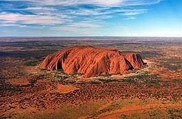
- see from above
- A country ‘beyond the edge’
- ochre and red
- the summit of a sandy undulation
- Charles Sturt
- Sidney Nolan
- oceanic metaphors of absence and longing
- central Australia/The centre of Australia
- James Cook
- claim the continent
- ‘wretched bareness’
- Ernest Giles
- John McDouall Stuart
- Alice Springs
- James Ross
- Overland Telegraph Line
- the State Library of South Australia
- Gum creek
- William Kekwick
- Benjamin Head
- Bill McKinnon
Looking For the Centre
https://www.ga.gov.au/scientific-topics/national-location-information/dimensions/centre-of-australia-states-territories
Officially, there is no centre of Australia. This is because there are many complex but equally valid methods that can determine possible centres of a large, irregularly-shaped area - especially one that is curved by the earth’s surface. However, numerous attempts at reaching and defining Australia’s centre were made during the country’s early pioneering days:
Charles Sturt
“Let any man lay the map of Australia before him, and regard the blank upon its surface, and then let me ask him if it would not be an honourable achievement to be the first to place foot at its centre. Men of undoubted perseverance and energy in vain had tried to work their way to that distant and shrouded spot.”
Instead, he discovered a sea of seemingly endless sand dunes - the Simpson Desert - and temperatures so extreme they shrivelled his supplies, prostrated his horses and burst his thermometer.
“Sunday, 22 April 1860, Small Gum Creek, under Mount Stuart, Centre of Australia - today I find from my observations of the sun, 111° 00’ 30”, that I am now camped in the centre of Australia. I have marked a tree and planted the British flag there.”
Return to Uluru 返回乌鲁鲁
https://northernterritory.com/cn/zh/uluru-and-surrounds
When Mark McKenna set out to write a history of the centre of Australia, he had no idea what he would discover. One event in 1934 – the shooting at Uluru of Aboriginal man Yokununna by white policeman Bill McKinnon, and subsequent Commonwealth inquiry – stood out as a mirror of racial politics in the Northern Territory at the time.
Black Inc.
Black Inc. is an independent Australian publisher of quality non-fiction, fiction and poetry.
Mark McKenna
马克·麦肯纳(历史学家)
马克·麦肯纳 (生于1959年)是纽约大学的历史学教授。 悉尼大学,因其在原住民历史方面的工作而著称
an ocean onto itself
The water surrounding the Antarctic continent is considered an ocean unto itself. Because a measurable physical difference in the ocean occurs at this point, the water surrounding the Antarctic continent is considered an ocean unto itself.
see from above
This is normally referred to as an aerial view; for example, OpenAerialMap is “The open collection of aerial imagery.
A country ‘beyond the edge’
(of the map?)
1 at or to a point on the other side of; at or to the further side of. beyond those hills there is a river. 2 outside the limits or scope of.
神秘?边缘?
ochre and red
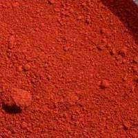

Ochre has been used for millennia by Aboriginal Australians for body decoration, sun protection, mortuary practices, cave painting, bark painting and other artwork, and the preservation of animal skins, among other uses.
the summit of a sandy undulation
Australian Aboriginals’ perceptions of their desert homelands
That anywhere in the deserts of Australia could be described as beautiful eluded the perceptions of the first European explorer to approach central Australia. On the 7th September, 1845, Captain Charles Sturt, who had passed over Sturt’s Stony Desert (as it became known) as he approached central Australia from the east, recorded:
From the summit of a sandy undulation close upon our right, we saw that the ridges extended north-wards in parallel lines beyond the range of vision, and appeared as if interminable. To the eastward and westward they succeeded each other like the waves of the sea. The sand was of a deep red colour, and a bright narrow line of it marked the top of each ridge, amidst the sickly pink and glaucous coloured vegetation around. [Familiar] as we had been to such, my companion involuntarily uttered an exclamation of amazement when he first glanced his eye over it. ‘Good Heavens,’ said he, ‘did ever man see such country!’ Indeed, if it was not so gloomy, it was more difficult than the Stony Desert itself. . . . (Sturt [1849] 1969, 1: 405-406).
Charles Sturt
Sidney Nolan
西德尼·罗伯特·诺兰爵士,OM,AC(英语:Sir Sidney Robert Nolan,1917年4月22日-1992年11月28日)是一位澳大利亚画家,代表作是《奈德·凯利》系列。
oceanic metaphors of absence and longing
central Australia/The centre of Australia
中澳大利亚(英语:Central Australia),又称爱丽丝泉地区(Alice Springs Region),是北领地的五个区域之一,其中心城镇是爱丽丝泉。中澳大利亚位于北领地的南部,和西澳大利亚州及昆士兰州接壤。中澳大利亚的人口约有5至6万人。这一地区的气候十分干燥
James Cook
海军上校)詹姆斯·库克,FRS,RN[?](英语:James Cook,1728年11月7日-1779年2月14日[注 1]),人称库克船长(Captain Cook),英国皇家海军军官、航海家、探险家、制图师,他曾经三度奉命出海前往太平洋,带领船员成为首批登陆澳大利亚东岸和夏威夷群岛的欧洲人,也创下首次有欧洲船只环绕新西兰航行的纪录。
直到1770年3月31日,他们驶离新西兰,继续往西探索,终于在4月19日抵达澳大利亚大陆东南方海岸(今澳大利亚新南威尔士州一带),立下欧洲人首次抵达澳大利亚东岸的创举。[22]库克有感当地景致与威尔士南部格拉摩根郡相似,遂将之命名为新威尔士,后来又改为新南威尔士。[13]
4月23日,库克在周记中纪录了他在波尔利角&action=edit&redlink=1)(Bawley Point)附近的布鲁舒岛(Brush Island)岸边直接见到澳大利亚原住民的情况,他写到:“……他们的颜色像相当深色或黑色,但我可不知道这究竟是他们真正的肤色,抑或是衣服的颜色。”[23]在4月29日,库克与随员在现称为科内尔半岛(Kurnell Peninsula)的岸边正式着陆,由于随船植物学家约瑟夫·班克斯和丹尼尔·索兰德在该处发现不少独特的物种,因此库克又将该处命名为“植物湾”(Botany Bay)。在那里,库克还首次与一名叫格威盖尔(Gweagal)的原住民进行接触和交流。[24]
从植物湾离开后,库克一行人乘奋进号向北进发,但旅途不太顺利。6月11日,奋进号在大堡礁一处浅滩触礁受损,随后又于6月18日误进一处河口。[25]连串事故使奋进号船身严重受损,被迫待在一处海滩(今奋进河河口的库克镇港口附近一带)上进行修理,使整个航程延误近七个星期。[3]奋进号维修过后重新出发,驶经澳大利亚北端的托利斯海峡,亲自证实了澳大利亚大陆与新几内亚并不相连。[10]未几,库克于8月22日在澳大利亚北端登陆新发现的占领岛&action=edit&redlink=1)(Possession Island),并以英王乔治三世)之名宣布该岛与整个新南威尔士为英国领土。[11]此后,库克一行转往巴达维亚(今印尼雅加达),但不少船员在当地感染疟疾死亡,几经波折,奋进号最后途经好望角和圣赫勒拿岛,终于1771年6月12日返抵英格兰唐斯(The Downs)。
但从测绘的资料所得,澳大利亚大陆的规模仍然不及那块神秘大陆,因此那块大陆是否存在,在当时仍然是一个谜。一般相信,如果这块“未知的南方大陆”是存在的,就应该比澳大利亚大陆位处更南的地方,而亚历山大·达尔林普尔等皇家学会成员则始终相信,这块南方大陆是确实存在的。
claim the continent
‘wretched bareness’
https://www.wordswithoutborders.org/article/the-wretched-of-uhuru
[
](https://www.wordswithoutborders.org/article/the-wretched-of-uhuru)
Ernest Giles
欧内斯特·贾尔斯
William Ernest Powell Giles (20 July 1835 – 13 November 1897),[2] best known as Ernest Giles, was an Australian explorer who led five major expeditions to parts of South Australia and Western Australia.
John McDouall Stuart
生平
约翰·麦克道尔·斯图尔特(英语:John McDouall Stuart,1815年9月7日-1866年6月5日),经常被简称为麦克道尔·斯图尔特(McDouall Stuart),是苏格兰裔探险家,亦是澳大利亚成就最显赫的内陆探险家之一。
斯图尔特曾带领澳大利亚首个探索团队,从南到北跨越澳大利亚大陆,并且成功折返。虽然面对险峻的环境,由于斯图尔特的经验和对团队的照顾,旅途中没有损失任何一位队员。斯图尔特的探索最终于1863年导致大片土地并入南澳大利亚州政府,这遍土地及后被称为北领地,至1911年联邦政府将之接管。1871至72年间,澳大利亚陆上电报线架设在斯图尔特的探索路径之上,这路径亦成为了连接奥古斯塔港与达尔文)的主要道路。至1942年,这道路获时任澳大利亚总督的高里所推荐,正式命名为斯图尔特公路,以记念他对澳大利亚的重大贡献
Alice Springs
景点介绍
爱丽斯泉(Alice Springs)是一座坐落于澳大利亚中部常年干涸的托德河岸边的小镇,拥有30,000人口。
James Ross
Overland Telegraph Line
澳大利亚陆上电报线
这 澳大利亚陆上电报线 是3,200公里(2,000英里) 电报 连接的线 达尔文 和 奥古斯塔港 在 南澳大利亚。陆上电报线于1872年完工,可以在澳大利亚和世界其他地区之间进行快速通信。随着1877年的完成,又增加了一个部分。 西澳大利亚人 该行的一部分。那是伟大的之一 工程 19世纪澳大利亚的壮举[1] 可能是最重要的里程碑 澳大利亚电报的历史
the State Library of South Australia
南澳大利亚州立图书馆,位于南澳大利亚州首府阿德莱德市(Adelaide)中心著名的北大街(North Terrace)上,紧邻南澳大利亚博物馆
南澳大利亚州立图书馆的前身是创办于1834年的南澳大利亚读写协会,经过数次变更名称,于1967年起改为现在的名字,几乎与阿德莱德城市同时成长,见证了历史。图书馆内有报刊、普通藏书、珍稀藏书、儿童读物(仅各类儿童读物就超过65,000种)和丰富的非图书的文物收藏,收藏了古老的、数量众多的图书资料等。虽然这里的阅览室肯定比不上维也纳的奥地利国家图书馆富丽堂皇的皇室气派,不过却更有那种“图书馆”的学术感觉,而且还带有那种英伦范儿的历史沧桑感。
Gum creek
William Kekwick
https://zh.ert.wiki/wiki/John_McDouall_Stuart
威廉·凯克威克(William Kekwick)仍然是他的同伴,以他的坚定不移而著称,他将在斯图尔特的整个职业生涯中留下来,通常是在斯图尔特前行时组织补给基地。凯克威克(Kekwick)向南去觅食,增加了人手,带着13匹马返回,配给了三个月,但只有一个人。本杰明·海德。
Benjamin Head
Bill McKinnon
比尔·麦金农
比尔·麦金农(Bill McKinnon)的故事。 1934年,他开枪打死了一名名叫约库纳纳(Yokununna)的男子。麦金农1931年加入斯图亚特的部队,两年后,该镇更名为爱丽丝·斯普林斯(Alice Springs)。他强硬、冒险、魅力十足,独自在大片地区巡逻。这意味着要执行一项命令,就像麦肯纳所说的那样, “千禧一代的黑发拉圣地几乎一夜之间就变成了白发拉前哨” ,白人法律用来为盗窃辩护。

若有收获,就点个赞吧
0 人点赞
