Raster栅格对象
常用方法
打开栅格数据
Raster(inRaster) #数据类型:Raster# 例子r = Raster("c:/data/dem") # 绝对路径r = Raster("19960909.img") #相对路径,当不是ArcGIS的栅格数据时,要加上后缀
保存栅格数据
rasterObj.save(path) #使用:Raster对象.save(路径字符串)# 例子r.save("c:/data/dem_1") # 绝对路径保存
列出工作目录下的所有栅格
arcpy.ListRasters({wild_card},{raster_type})# 例子:列出工作空间中的Grid栅格名称import arcpyarcpy.env.workspace = "c:/data/DEMS"rasters = arcpy.ListRasters("*","GRID")for raster in rasters:print raster
| 参数 | 说明 | 数据类型 |
|---|---|---|
| wild_card | 通配符可限制返回的结果,例如匹配前面有A的文件名(“A*”) | String |
| raster_type | 栅格格式 | String |
栅格转换为NumPy数组
使用例子:https://blog.csdn.net/summer_dew/article/details/78867410
转换成NumPy便于我们对像元进行操作,详细请点我
RasterToNumPyArray (in_raster, {lower_left_corner}, {ncols}, {nrows}, {nodata_to_value})
RasterToNumPyArray支持将多波段栅格直接转换成多维数组(ndarray)
- 如果输入Raster实例基于多波段栅格,则会返回 ndarry,其中第一维的长度表示波段数。ndarray 将具有维度(波段、行、列)
- 如果输入Raster实例基于单个栅格或多波段栅格中的特定波段,则会返回含维度(行、列)的二维数组。
转换时隐含规则:
- 如果数组的定义(左下角以及行数和列数)超出 in_raster 的范围,则数组值将分配为 NoData
- 如果 lower_left_corner 与像元角不重合,则会自动捕捉到最近像元角的左下角,该捕捉方法采用的规则与“捕捉栅格”环境设置中的规则相同。RasterToNumPy 函数内的捕捉操作不会与“捕捉栅格”环境设置相混淆;该函数只使用相同的交互
属性
| 属性 | 说明 | 数据类型 | 属性 | 说明 | 数据类型 |
|---|---|---|---|---|---|
| bandCount | 波段数量 | Integer | pixelType | 像素类型(U32:Unsigned 32 bit integers) | String |
| name | 数据名称 | String | spatialReference | 空间参考 | SpatialReference |
| path | 完整路径和名称 | String | catalogPath | 全路径和名称的字符串 | String |
| compressionType | 压缩类型 | String | format | 数据格式 | String |
| extent | 栅格数据的范围 | Extent | hasRAT | 存在关联的属性表 | Boolean |
| height | 行数 | Integer | width | 列数 | Integer |
| isInteger | 数据具有整数类型 | Boolean | isTemporary | 数据是临时的 | Boolean |
| maximum | 最大值 | Double | minimum | 最小值 | Double |
| mean | 平均值 | Double | standardDeviation | 标准差 | Double |
| uncompressedSize | 磁盘大小 | Double | noDataValue | 在数据中NoData的值 | Double |
操作
【官方文档】
out_raster=in_raster1*in_raster2 #直接运算out_raster = Slope("dem") #指定函数:参数为字符串,全路径或相对路径out_raster = Con(in_raster >= 2, 1, 0) #栅格计算器中的函数outStats = CellStatistics(["inraster1", "inraster2", "inraster3"], "MEAN", "DATA") #平均值
案例
| 名称 | 说明 |
|---|---|
| 多个栅格文件相加 | 创建一个相同范围,像元值都为0的栅格文件aoi_value_0,递归相加,保存 |
镶嵌(求多幅影像的平均值)
def mosaic(in_dir, out_fp):# inputin_datas = []fns = os.listdir(in_dir)for fn in fns:if fn.endswith("tif"):fp = os.path.join(in_dir, fn)in_datas.append(fp)print "\t[data] {}".format(fp)if len(in_datas) == 0:print "\t[No data] {}".format(in_dir)return Noneelse:print "\t[find data] {}".format(len(fns) )# copy out_dataprint "\t[new] create the out file"first_data = in_datas[0]out_raster = Raster(first_data)out_raster.save(out_fp)# Mosaicprint "\t[doing]"arcpy.Mosaic_management(in_datas[1:], out_fp, "MEAN")print "\t[done]"return out_fp
求多幅影像的平均值(去除最大值、最小值)
def mosaic_nomaxmin(in_dir, out_fp):# inputenv.workspace = in_direnv.extent = "MAXOF"in_datas = []fns = os.listdir(in_dir)for fn in fns:if fn.endswith("tif"):in_datas.append(fn)print "\t[data] {}".format(fn)if len(in_datas) == 0:print "\t[No data] {}".format(in_dir)return Noneelse:print "\t[find data] {}".format(len(fns))# max and min rastersum_raster = CellStatistics(in_datas, "SUM", "DATA")max_raster = CellStatistics(in_datas, "MAXIMUM", "DATA")min_raster = CellStatistics(in_datas, "MINIMUM", "DATA")# the number of Datacnt_raster = Con(IsNull(sum_raster), 0, 0)for data in in_datas:cnt_raster = Con( IsNull(data), cnt_raster, cnt_raster+1 )# cnt_raster.save(r"F:\out\cnt.tif")# computeprint "\t[doing]"raster = (sum_raster - max_raster - min_raster) / ( cnt_raster - 2)raster.save(out_fp)print "\t[done]"return out_fp
求多幅影像的中值
def mosaic_median(in_dir, out_fp):# inputenv.workspace = in_direnv.extent = "MAXOF"in_datas = []fns = os.listdir(in_dir)for fn in fns:if fn.endswith("tif"):in_datas.append(fn)print "\t[data] {}".format(fn)if len(in_datas) == 0:print "\t[No data] {}".format(in_dir)return Noneelse:print "\t[find data] {}".format(len(fn))# computeprint "\t[doing]"raster = CellStatistics(in_datas, "MEDIAN", "DATA")raster.save(out_fp)print "\t[done]"return out_fp
错误集合
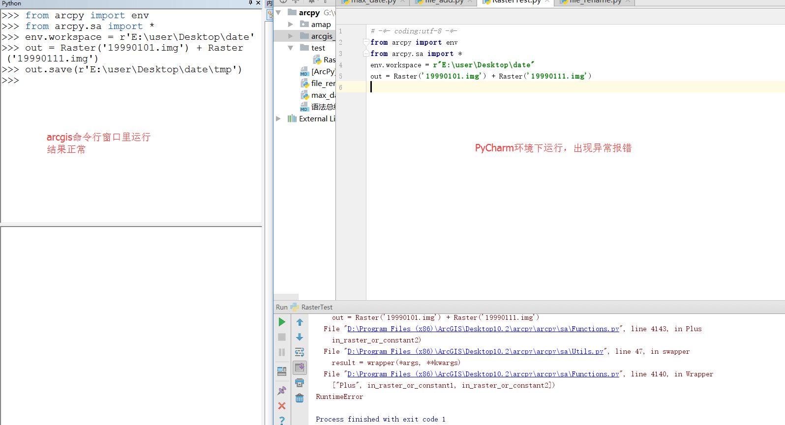
运行py文件出错
运行py文件出错,没有为脚本提供授权
错误:
Traceback (most recent call last):File "G:/workspace/python/arcpy/arcgis_running/file_add.py", line 6, in <module>out = Raster('19990101.img') + Raster('19990111.img')File "D:\Program Files (x86)\ArcGIS\Desktop10.2\arcpy\arcpy\sa\Functions.py", line 4143, in Plusin_raster_or_constant2)File "D:\Program Files (x86)\ArcGIS\Desktop10.2\arcpy\arcpy\sa\Utils.py", line 47, in swapperresult = wrapper(*args, **kwargs)File "D:\Program Files (x86)\ArcGIS\Desktop10.2\arcpy\arcpy\sa\Functions.py", line 4140, in Wrapper["Plus", in_raster_or_constant1, in_raster_or_constant2])RuntimeError


解决:
添加授权:arcpy.CheckOutExtension("spatial")
import arcpyfrom arcpy import envfrom arcpy.sa import *arcpy.CheckOutExtension("spatial")env.workspace = "E:/user/Desktop/date"out = Raster('19990101.img') + Raster('19990111.img')
统计多个栅格的平均值 报错
【代码】
def mosaic_median(in_dir, out_fp):# inputenv.workspace = in_dir# env.extent = "MAXOF"in_datas = []fns = os.listdir(in_dir)for fn in fns:if fn.endswith("tif"):in_datas.append(fn)print "\t[data] {}".format(fn)if len(in_datas) == 0:print "\t[No data] {}".format(in_dir)return Noneelse:print "\t[find data] {}".format(len(fn))# computeprint "\t[doing]"raster = CellStatistics(in_datas, "MEDIAN", "DATA")raster.save(out_fp)print "\t[done]"return out_fp
【报错】
Traceback (most recent call last):File "D:/mycode/GISandPython/2Arcpy/ArcGISTools/2MOD04-L2/process.py", line 223, in <module>mosaic_all(ret, case)File "D:/mycode/GISandPython/2Arcpy/ArcGISTools/2MOD04-L2/process.py", line 216, in mosaic_allmosaic_median(month_dir, out_fp)File "D:/mycode/GISandPython/2Arcpy/ArcGISTools/2MOD04-L2/process.py", line 189, in mosaic_medianraster = CellStatistics(in_datas, "MEDIAN", "DATA")File "C:\Program Files (x86)\ArcGIS\Desktop10.5\ArcPy\arcpy\sa\Functions.py", line 3149, in CellStatisticsignore_nodata)File "C:\Program Files (x86)\ArcGIS\Desktop10.5\ArcPy\arcpy\sa\Utils.py", line 53, in swapperresult = wrapper(*args, **kwargs)File "C:\Program Files (x86)\ArcGIS\Desktop10.5\ArcPy\arcpy\sa\Functions.py", line 3145, in Wrapper[function] + Utils.flattenLists(in_rasters_or_constants))RuntimeError: <exception str() failed>
【错误分析】多个栅格的范围不一致导致的错误
【解决】多加一句环境配置env.extent = "MAXOF"

