PostGIS是PostgreSQL对象关系数据库的空间数据库扩展器。它添加了对地理对象的支持,允许在SQL中运行位置查询。除了基本的位置感知功能,PostGIS还提供了许多其他竞争空间数据库(如Oracle Locator/ spatial和SQL Server)很少有的功能。
PostGIS 依赖了下面这些软件:
PostgreSQL
GEOS
SFCGAL
GDAL
PROJ
protobuf-c
json-c
PostGIS 严格地要求所依赖软件的版本。如果你用源码安装PostGIS,在安装之前,你应该安装官方建议的依赖版本。
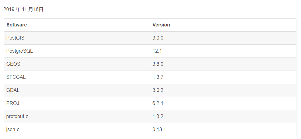
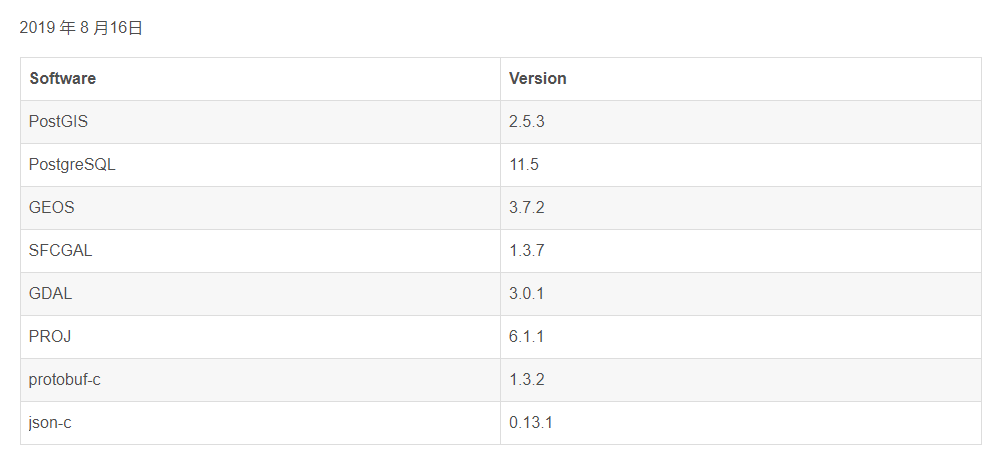
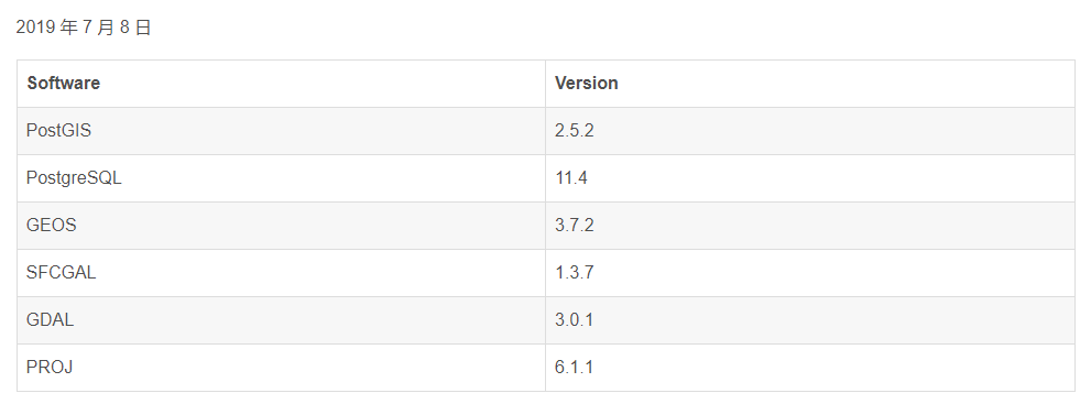
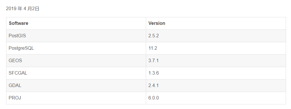
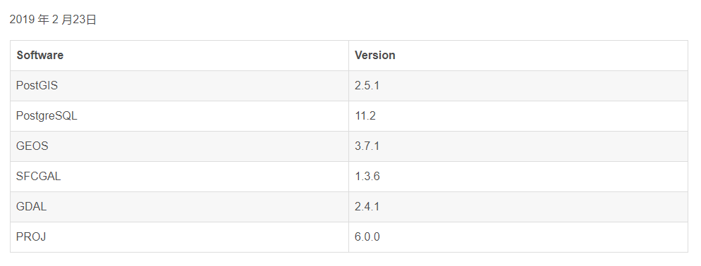
笔者从官方文档 中获取了 每一个版本的 PostgreGIS 所依赖的软件列表。
整理如下: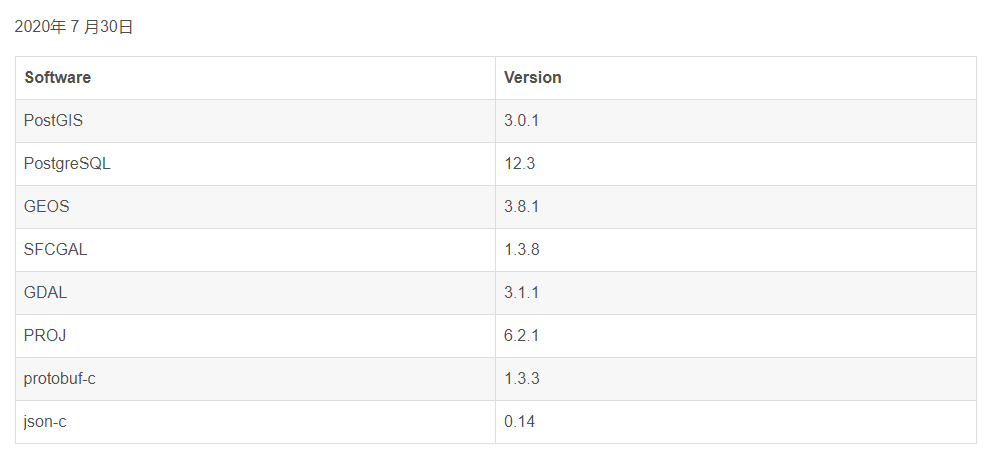
参考
[1]compatibility and support matrix. Edgewall Software. 16 August 2020.
English
PostGIS is a spatial database extender for PostgreSQL object-relational database. It adds support for geographic objects allowing location queries to be run in SQL.
In addition to basic location awareness, PostGIS offers many features rarely found in other competing spatial databases such as Oracle Locator/Spatial and SQL Server.
PostGIS relies on the following software:
PostgreSQL
GEOS
SFCGAL
GDAL
PROJ
protobuf-c
json-c
The author obtained the list of software on which PostgreGIS depend for every PostgreGIS version from the official documentation.
————————————————
版权声明:本文为CSDN博主「江天水一泓」的原创文章,遵循CC 4.0 BY-SA版权协议,转载请附上原文出处链接及本声明。
原文链接:https://blog.csdn.net/international24/article/details/112605356
————————————————
版权声明:本文为CSDN博主「江天水一泓」的原创文章,遵循CC 4.0 BY-SA版权协议,转载请附上原文出处链接及本声明。
原文链接:https://blog.csdn.net/international24/article/details/112605356

若有收获,就点个赞吧
0 人点赞
