
(CNN) — You’re in Hangzhou. You gaze upon lush hillsides in the near distance and wish you knew the best places to get out for a walk into the countryside.
Wish no more. With this handy guide to some of Hangzhou’s easiest and most scenic hikes, you can be out of the city sprawl and into the deep woods in barely the time it takes to scarf a power bar and fill a water bottle.
If you’re feeling adventurous, all four of the suggestions below can be linked into one long trail.
1. Zhejiang University (Yuquan Campus) to Bei Gao Feng
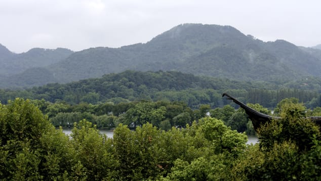
The dramatic West Lake in Hangzhou.
Courtesy J Aaron Farr/Creative Commons/Flickr
Distance: 3.5 kilometers
Level: Easy
This well-trafficked path is neither long nor difficult, but the views are majestic.
Start by entering Zhejiang University’s Yuquan Campus at the east entrance.
After giving a hearty salute to the Chairman Mao statue in the main commons area, make your way west to the very rear of the university, where you can ascend Laohe Shan (老和山).
From here, head southwest toward North Peak (Bei Gao Feng).
The stone path here is mostly level. The panoramic views of West Lake and the surrounding hill country are gorgeous.
Start: Zhejiang University (Yuquan Campus) east entrance, corner of Yugu Lu and Zheda Lu 浙江大学玉泉校区东门, 玉古路和浙大路口
End: Bei Gao Feng (North Peak), past the end of Lingyin Lu, north of Lingyin Temple 北高峰, 灵隐路到底后一直走, 在灵隐寺北边
Best Hangzhou dishes
2. Lingyin Temple to Hupao Shan
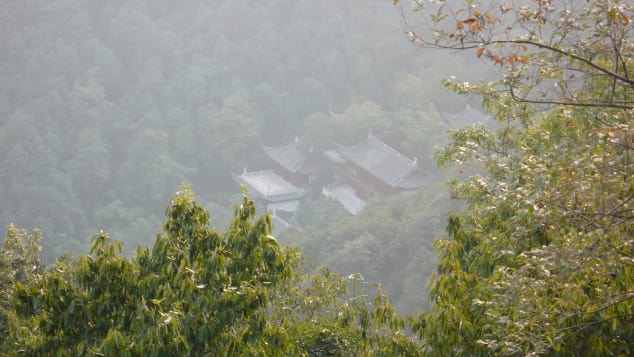
Courtesy Banalities/Creative commons/Flickr
Distance: Approximately 12 kilometers
Level: Moderate
South of Bei Gao Feng lies one of the largest and most ornate Buddhist temples in China, the Temple of the Soul’s Retreat, or Lingyin Temple (灵隐寺).
You’ll also find a direct path to Mei Ren Peak (Mei Ren Feng 美人峰), and the start of the biggest and baddest portion of the trek.
This hike can take up an entire afternoon, so brace yourself to traverse low valleys and minor cliffs — there are a number of difficult but rewarding ascents and descents — that pass by temples, pagodas, bamboo forests and tiny villages in forest clearings.
There are a number of ways to reach Hupao Shan, but the most scenic is the bucolic Shi Li Lang Dang (十里琅珰). Its winding stone paths are flanked by tea fields and modest trees, leading up to Five Clouds Hill (Wu Yun Shan 五云山).
From here, walk eastward across burbling streams and lonely pavilions, past Dahua Shan and the Six Harmonies Pagoda (Liuhe Ta 六和塔) to the south. After climbing up Tiger Spring Mountain (Hupao Shan) you’ll find good views and places to rest. The top of mountain reveals a hushed oasis amid a sea of trees, with West Lake looming in the distance.
Start: Lingyin Temple, 1 Lingyin Road 灵隐寺, 灵隐路法云弄1号, +86 571 8796 0292,
End: Hupao Shan, south of Hangzhou Zoo, west of Hupao Lu 虎跑山, 杭州动物园以南, 虎跑路以西
3. Longjing Village to Jiuxi Scenic Area
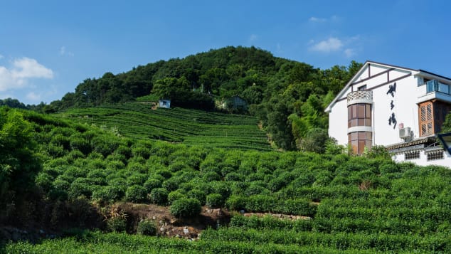
Explore the tea fields where Longjing green tea originates.
Courtesy Vladimir K/Creative Commons/Flickr
Distance: Approximately 4 kilometers
Level: Very easy
Hangzhou’s world-renowned Longjing green tea originates in small Longjing village, located just a little ways outside the city center. This is where the Jiuxi Scenic Trail begins.
Getting to the trailhead is a lush adventure in and of itself. The route to the village passes tea fields, wetlands and a landscape sculpted to pastoral perfection.
At the single main fork on the village road, bear left. At the end of the road you’ll find the nondescript starting point of one of the most idyllic trails around the city.
This path is entirely flat, easy for children and anyone else who can put one foot in front of the other.
Well-known yet somehow secluded, the trail skips across clear streams on conveniently placed stones. Side stairways lead to grandiose Buddhist monasteries. The trail ends at the Jiuxi Scenic Area, where dragonflies buzz around a quaint, blue-green lagoon with a pretty waterfall.
Start: Longjing Village, end of Longjing Lu. Bear left at the fork in the main road and follow the road to its terminus 龙井村, 龙井路到底, 到三岔口选最左边的路, 走到头
End: Jiuxi Scenic Area, near Jiuxi Lu and Zhijiang Lu 九溪景区, 近九溪路和之江路口
Hangzhou, China: 10 things it does better than Shanghai
4. Hupao Shan to Wu Shan Square
Distance: Approximately 5 kilometers
Level: Moderate
The final leg of your epic journey — should you choose to attack all of the paths listed here at once — winds its way from Hupao Shan back to the city center’s Wu Shan Square (吴山广场).
Cross Hupao Lu, then walk up and over Dachi Shan (大慈山) to Jade Emperor Hill (Yuhuang Shan 玉皇山). At Jade Emperor Hill you’ll find ornate pavilions, temples, memorial halls and a view of Hangzhou’s massive, Daoist, Eight Triagrams farming field (Bagua Tian 八卦田).
Make your way along the well-posted trail toward Phoenix Hill (Fenghuang Shan 凤凰山), and finally north to Wu Shan itself. Its iconic Chenghuang Temple (Chenghuang Ge 城隍阁) looms over Wu Shan Square, where you can finally collapse at one of many quality restaurants nearby.
Start: Hupao Shan, south of Hangzhou Zoo, west of Hupao Lu 虎跑山, 杭州动物园以南, 虎跑路以西
End: Wushan Square, end of Yan’an Nan Lu 吴山广场, 延安南路到底
The official Hangzhou map, showing peak locations, scenic spots and main hiking trails, can be purchased at any newsstand around Hangzhou city.
The English version can be obtained for free at the Hangzhou Tourism Information Center 228 Yan’an Nan Lu, near Kaiyuan Lu 延安南路228号, 近开元路, 9:30 a.m.-7 p.m., +86 571 8792
It was published here https://www.cnn.com/travel/article/hangzhou-best-hiking-trails/index.html

若有收获,就点个赞吧
0 人点赞
